Sunday, June 6, 2010

Severe Weather Threat For June 7th

A very interesting scenario is setting up for portions of the Tri-State region on Monday. A shortwave within the ridge of high pressure that is centered over the area will rotate over the area on Monday. ESE winds at the surface will advect more moisture in to the Tri-State region. Dew points look to be in the low to mid 60s by tomorrow afternoon across southeast Wyoming...WOW!! The result will be a huge amount of Cape along the Front Range (3000-4000 j/kg).


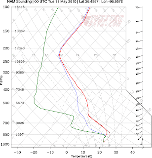
The one issue that looks like will be a big problem would be the very strong capping inversion that is going to be sitting above most of the area. 700 mb temperatures look to be in the 15-18 degree range through 6:00 PM, far to warm for initiation. The GFS continues to show the cap holding strong until the late evening hours when temps aloft finally cool while the WRF/NAM show some isolated development, mainly in Wyoming.
Have decided to side with the WRF/NAM on this one, although some of its coverage may be a little on the high end. 700 mb temperatures across east-central Wyoming are much cooler and thunderstorms should initiate up there. Outflow boundaries will move south out of those storms and will most likely collide with boundaries from storms on Sunday that will be pushed against the Laramie Range. These boundaries will be the focal point for storm initiation.
By 00Z, the capping inversion looks to weaken along the I-25 corridor in Wyoming. At this time, if the timing is correct, outflow boundaries from storms to the north will collide with other boundaries along the Cheyenne Ridge/Laramie Range giving updrafts a slightly stronger push up to potentially break the cap where it is weak enough in SE Wyoming.
Northern Colorado should stay capped through the afternoon as the cap is much stronger. I would expect the cap will weaken a bit between 00-03Z just in time for southbound outflow boundaries from storms in Wyoming to provide areas of convergence in northern Colorado, at which time CAPE values appear to be very impressive. Most of the convection should occur in Colorado after 3Z.
Whats the threat?!?!?!?!?
Strong CAPE values would indicate the potential for some very strong updrafts. Surface to 500mb bulk shear values appear to be in the 50-60 kt range, enough for the updrafts to remain rain/hail free. There are at times brief veering wind profiles across the area as a surface low in SE Colorado keeps winds at the surface in a ESE direction with winds aloft from the WSW in the quasi-zonal flow.

As of now feel the primary threat will be large destructive hail and damaging winds. However, if LCL's can remain in the 750-1000 m range a few isolated tornadoes can not be ruled out. The threat for severe weather will exist between 4:00 PM and 8:00 PM for SE Wyoming and will shift south and east between 8:00 PM and 12:00 AM for northern Colorado. I feel that storm chasers who park themselves in Cheyenne tomorrow afternoon/evening could enjoy a few very nice looking supercells....


Thursday, May 27, 2010

Chase Summary of May 23rd, Western Kansas

Well Decided to go out for a nice storm chase on Sunday the 23rd. All the ingreadients were coming together over western Kansas. My target was Goodland, KS for a late initiation between 6:00 pm and 7:00 pm. We arrived in Goodland around 4:00 pm as some storms had already fired along the dryline further south. We decided to go to Oakley and head south towards Scott City to intercept and watch the lonestorm that had developed. On our way down, we ran in to some hail and rain but for the most part stayed out of the hail core. We let the storm move up to the north and chose not to follow it as the storm became somewhat disorganized. Krista and I met up with Shep and Becca north of Scott City where we decided what the next move would be.

By now, the dryline was beginning to fire further north as a warm front moved through the area. A nice looking storm fired up near Leoti, Kansas. This storm showed some potential on radar and I was very tempted to head after it, but after looking at current conditions and model output for the next couple of hours we decided to head north as conditions would become much more favorable for tornadoes and the Leoti storm would be moving in that direction. We got back to Oakley as several thunderstorms fired up around us. Decided to head west and get in position for the now tornado warned Leoti cell. For a while this storm looked like it would be the storm to play as with every minute this storm was moving in to more favorable conditions. Unfortunatly the storm died out relativly quick as other storms to the north and west fired. Here we would begin to see a nice big lowering from another storm north of Winona, KS. We saw a funnel cloud nearly drop to the ground several times before it disappated. Other storm chasers in the area who had a better vantage point on the storm reported that the funnel cloud actually touched the ground, so chalk that one up for 1 tornado.

After that storm we headed north and west as several storms were beginning to converge over the Goodland, KS area. At this point the sun is beginning to set but we can see two seperate areas of lowering. We would pull off I-80 and do a little dirt road chasing. We would watch the storm for a while and watch as its inflow became sustained at about 30-40 mph. Eventaully, A tornado would become visible thanks to the light from the storms lightning. We observed this tornado for about 5 minutes before it lifted. We continued to watch the storm and enjoy its structure and light show. Another funnel became visible and hit the ground and was on the ground for maybe a minute, if that. So chalk up 2 more tornadoes.

We then followed the storm into Nebraska where Krista and I separted from Shep and Becca so we can make the journey home, very satisfied from our chase. The next day Ryan told me that he enhanced some of the pictures from that Goodland, KS storm and discovered that what we thought was a rainshaft on the right side of the tornado turned out to be a possible wedge tornado with the tornado we saw originally being a satellite tornado. So deepending an more analysis, we may have scored big with seeing 4 tornadoes on this chase.


Enhanced Image With Highlights


Enhanced Image


Raw Image

Sunday, May 9, 2010

Severe Weather Forecast For Monday May 9th, 2010


Well, looks like North-Central Oklahoma and Southern Kansas are goingto be in-store for an epic day with a good chance of tornadic supercells.
A short wave trough will be moving across northern New Mexico and Southern Colorado and in to Kansas through the day Monday. A dryline will set up across central Oklahoma with dewpoints in the upper 60s and low 70s across central and Eastern Oklahama. High dewpoints will be caused by good SSE flow at the surface advecting moisture from the Gulf of Mexico, but will be aided by a few lingering showers and thunderstorms from the previous night. If the showers last long enough, it will keep convection from developing. However, skies should clear enough in the early afternoon hours to allow temperatures to warm in to the 70s allowing the air mass to become extremely unstable. Models show CAPE values of 3000-3500 j/kg.

One potential problem that the models have hinted at was a potential for a strong cap, mainly through the early evening hours, which could limit convective activity. However, as the cold front collied with the dryline, surface convergance along the dryline and cold front should allow a few storms to break the cap early, which will cause the storms to explode.

Winds at the surface will be from the SSE at 15-20 kts with winds veering nicely at the lower levels of the atmosphere. A strong low level jet will be in place where winds at 850 mb will be at 65 kts, perfect for supercell thunderstorms.

A Potential Target

Feel the best target for tornadic thunderstorms will be across north-central Oklahoma, on the Northern Edge of thee 3000 J/kg CAPE bomb, it is here where we will see the best veering winds. Expect thunderstorms to fire between 5 and 6 PM central time. Discrete rotating cells will be likely prior to 8 PM before a whole line of thunderstorms fire making the primary threat large hail and damaging winds. So I would say Morrison, OK would be a good place to target for getting in to position see some tornadoes.


Tuesday, April 20, 2010

Severe Weather Potential for April 21st - 22nd

Tuesday April 20th Update

Models have backed off a bit on the severe weather potential for the Tri-State area with this next trough that begins to move in to the area on Wednesday afternoon/evening. I will be unable to chase this next storm, but I'm going to make a forecast as if I were going to chase this next system, just for kicks....

On Wednesday

NAM paints a good amount of CAPE over north-central Texas with temperatures in the 70's and 80's and dewpoints in the mid 60s. This will be the area where thunderstorms will fire. However, wind shear will be farily limited Wednesday before the trough begins to move through the area on Thursday. Expect very little in the form of rotating supercells.

On Thursday

NAM shows a very nice and well defined Dryline that cuts through SE Colorado with dewpoints in the 50's. Moisture wraps around a developing low that sets up south of Pueblo, Colorado. Directional wind shear in this area looks fantastic for at least the potential for a few tornadoes. The bad thing is, a cap exist east of Lamar where some of the best directional shear, at least in Colorado. The cap looks to break between the surface low and Lamar, Colorado leaving a very narrow area for thunderstorm development. Due to the cap, models have showed very little in the form of QPF over this area. However, I feel this area should be watched closely, because if a storm were to develop in this area, it could be a very photogenic supercell.

The bulk of the activity looks to be southeast of Lamar in to Oklahoma and Texas. Dryline will set up east of Amirillo, Texas. CAPE of 2,500 - 3,00 j/kg exist along the Texas/Western Oklahoma border. Low level directional shear looks on I-40 along the Texas/Oklahoma state line. However, I would look at someplace slightly further north, perhaps along a line from Perryton, Texas to Woodward, Oklahoma. SFC - 500mb Bulk shear looks great in this area, with great directional shear at the surface. It also plays a great role as a potential convergence zone with a more well defined dryline in the area. Models also depict a good amount of 0-1km helicity in this area. Models show this part of the dryline fireing first.

So if I were chasing, my target would be Booker, Texas.

Closer to home.....

Although models have decreased the severe potential for the Tri-State area on Thursday, I'm not yet sold that nothing will happen. Dewpoints will be in the mid 40s across the area with CAPE values of 750-1150 in Weld county. Tornado threat is practically non-existant anymore with wind shear looking to unidirectional. Wouldn't suprise me if we do see a few storms become severe with large hail and gusty winds, as winds aloft are strong enough to keep rain and hail out of the updraft allowing storms to live a little longer, therefore becoming stronger.

Sunday, April 18, 2010

Severe Weather Potential for April 21st - 22nd

OK....So here is the big picture....We have a large upper level low that will begin to move on shore in the Pacific NW beginning Monday evening. This upper level low will move in to the Tri-State area on Wednesday. So here is the potential set up on Wednesday...

All week long we've had SE winds pumping moisture in to the area. On Wednesday, dew points look to be in the mid to upper 40s with temperatures in the 50s and 60s, this is not that bad for the high plains of SE Wyoming. Southeasterly winds will be at the surface with southwesterlies aloft. CAPE values still look to be a little bit on the low side through Wednesday evening along with a fairly strong capping inversion. The capping in version looks to weaken in the late evening hours which should allow a few storms to develop. Wind shear doesn't look horrible Wednesday night, so could see a severe storm or two through the night.

Depending on what happens Wednesday, it could be a very busy day Thursday. Let's start of Thursday morning..... Hello!!! Dew points in the low 50s in Northeastern Colorado, going as far west as the Greeley area... Temperatures also appear to be in the low to mid 50s....FOG. A surface low looks to begin to develop east of Denver, if this low can deepen enough through 18z, winds will increase from an easterly direction between Denver and Cheyenne. At this time, a nice southerly 50 kt jet is lined up along the front range.

This storm is very similar to the situation we had on May 22nd, 2008. I agree that the greatest severe weather potential will be across Western Kansas. However, if the fog that develops Thursday morning can break between 9 AM and 10 AM, surface heating may heat up the surface enough to allow a few thunderstorms to explode and become severe and potentially tornadic in a matter of minutes.....

Saturday, April 10, 2010

Severe Weather Potential 4/11-4/13

Sooooooo.....We have a large Pacific trough that sets up over the western U.S. This trough will swing pieces of energy that will allow thunderstorms to develop and potentially go severe...

Sunday-This is probably going to be the best day for tornadoes as this storm moves through the area. Latest NAM runs suggest a CAPE bomb of 2800-3000 j/kg in southern Kansas/northern Oklahoma with good directional wind shear, especially in the sfc-700 mb layer. However the speed sheer is not all that great due to a lack of a strong pressure gradient. Dewpoints look to be in the 60s across central Kansas/Oklahoma. NAM/WRF show a few discrete cells developing after breaking the cap. The cells will be slow moving to nearly stationary due weak flow aloft, but with them binge very isolated, they will be very photogenic. If enough convergence develops at the surface and winds at the surface can increase a bit, a tornado or two will be possible.

If I were going to chase I would stay in southern Kansas between Dodge City and Wichita.

Monday and Tuesday-The severe weather threat on these days will primarily be large hail and damaging winds and will be across the high plains and closer to home. Directional wind shear is really not all that impressive. A few isolated thunderstorms will be possible late Monday afternoon/evening. Shear is fairly unidirectional, except in the Dakotas where there is a little bit more of an easterly component to the surface winds. Dewpoints will be in the mid 40s and 50s from eastern Colorado through the Nebraska Panhandle. Southerly winds will aid in advecting moisture from the southern plains. A few storms will fire but shear is not favorable for tornadic supercells

Tri-State region

Across my viewing area, severe weather threat will be limited on Monday due to a dry lower atmosphere. Expect a few thunderstorms to fire in the afternoon and evening, but with a dry lower atmosphere and LCL's over 2500 m above the surface, the only threat from theses storms will be gusty winds from evaporating rainfall and downbursts.

Moisture advection will increase Monday night with a 5-15 mph southeasterly wind across the Panhandle and SE Wyoming. A cold front will move through the region on Tuesday which will be the lifting mechanism. Wind shear ahead of and along the cold front will be mainly unidirectional which would take out any threat of tornadoes. With that said large hail and damaging winds will be possible. CAPE values are really not all that impressive, but for the high plains the values are large enough for a few storms. Another issue will be the potential for heavy rainfall with precipitable water values approaching 0.8" The greatest tornado threat will occur over the Dakotas where there is a more easterly component to the surface winds, but with that said the shear is still not all that impressive.

Friday, April 9, 2010

First Severe Weather Event of 2010??????

Forecast as of 4/9/2010

Mild spring weather looks to continue through the weekend for the Tri-State area. With the exception of a few isolated thunderstorms on Saturday and possibly Sunday, things are looking pretty good.

Models show the possibility of a few isolated thunderstorms firing on the Laramie range Saturday afternoon. CAPE and Lifted Indecies suggest a few isolated storms will be possible. There is a strong cap in place over locations east of I-25, so won't expect any shower activity east of I-25. Decided to throw in a slight chance of an Isolated thunderstorm for southeast Wyoming and Northern Colrado for the slight chance that a thunderstorm will reach I-25 and will effect Cheyenne and/or Fort Collins.


Severe Weather Forecast For Monday-Tuesday

Timing of the Fropa has change over the past couple model runs and has held off the front until Tuesday. The severe weather threat looks to be the greatest on Tuesday across the region along the cold front.

GFS is a little wacky and still is a little too fast with this system, so I will trust the Euro and wait for the NAM's output. As of the 18z model runs, the GFS is a little faster and less amplified than the Euro. The GFS practically moves any chance of severe weather over central Nebraska. Also, 18z GFS shows a lee cyclone setting up over northeastern Colorado which could help turn winds easterly across northern Kansas and Central Nebraska increasing the chance of tornadoes across those regions, on the other hand, the bulk shear lies over southeast Wyoming and the Panhandle of Nebraska.

Euro looks the most promising for a potential severe weather event across Southeast Wyoming and the Nebraska Panhandle. Trough is a little more amplified compared to the GFS and is a little slower. Lack details from the Euro, so will wait until tomorrow's NAM to get it's details as it appear the NAM and Euro are showing similar results through Monday. Forecast updates will be done through the weekend.

Thursday, April 8, 2010

A Nice Spring Week!

Forecast as 4/8/2010

Well it's been a pretty nice day as high pressure is bringing the area plenty of sunshine and mild temperatures. We have a little cold front on the way that wont bring much of anything to the area on Friday. Models have shown a little bit more moisture in the last 24 hours compared to what they were showing earlier this week, but still feel the Cheyenne area or even my viewing area will see much with it.

Expect clouds to increase and temperatures to remain generally steady after the front moves through the area on Friday. Could see a few afternoon t-storms in the mountains and possibly over Laramie. Other than that the viewing area should see minimal shower activity as I expect the heaviest activity to be north of a line from Wheatland to Torrington.

Saturday should be pleasant with perhaps a stray mountain shower or Thunderstorm.

Next storm to affect the area will swing in Monday and Tuesday. Expect scattered showers and thunderstorms from this system. One wave of energy will move through the area on Monday night and eject to the northeast. GFS and ECMWF differ on evolution of this shortwave. GFS is further north while ECMWF is furthur south. If the GFS solution pans out, the best chance of severe weather will probably be across central Nebraska or even parts of South Dakota. With that said, I'm not all that impressed with the development of this storm system. CAPE looks a little weak, with dew points in the 50s and low 60s and with every model run the wind shear looks a little less impressive.

So if your looking for a chase on Monday, hope for Euro solution with a slightly further south track, that may just kick up the instability and wind shear needed for tornadic supercells in western and central Kansas and possibly western Texas.

Wednesday, April 7, 2010

Mild and Dry Weather on the Way!!!


Forecast as of 4/7/2010


Well the snow ended as expected before sunrise with generally clear skies through much of Wednesday. My snow forecast looks like it might have barely verified with Cheyenne looking like we saw maybe a little over 2.0". Snow fall rates turned out to be a little lower than I expected allowing snow to generally melt faster than it could stick.


One more little issue in this forecast before high pressure brings some relatively quiet weather to the area. There is a small upper level disturbance that was moving out of Montana as of 19z. This disturbance is coming on the back side of the upper level trough that moved through last night. A nice little jet streak is accompanying this energy with the Tri-State region being located on the jet streak's left exit region. In addition, the recent snow has already melted and now the ground is becoming warmer as it absorbs more sunlight. Low level moisture and day time heat will all CAPE values to be between 500 and 600 J/kg. The combination of the jet streak producing lift and the "warm/moist" air at the surface should be enough to kick off some isolated showers and perhaps even some thunder!


The WRF and NAM are drier than the GFS, but both hint at most of the shower activity remaining in Colorado. This would make sense as temperatures in Colorado are warmer this afternoon, and the jet streak will be moving through SE Wyoming and the Panhandle through 9:00 PM which will shift the best south and east of the area.


High pressure will move in behind this energy allowing highs to reach the 50s. A weak cold front will bring more clouds to the area Friday, but nothing more. The weekend looks great with highs in the 50s and 60s.


Next large trough moves in to the area Monday with a chance of isolated thunderstorms and rain showers.

Tuesday, April 6, 2010

Weather Forecast as of 4/6/2010


Last night's forecast has verified nicely with showers wrapping up shortly around midnight for Cheyenne and dry conditions for extreme southeastern Wyoming under downslope winds and subsidence aloft. Temperatures did warm a little bit more than expected, but not to worry snow showers as of 23Z were beginning to drop southward toward the area.


As of 23Z, upper level low was just southeast of Cheyenne and pushing further to south and southeast. As low moves southward, upper level dynamics will be in place along with a shallow upslope flow to create moderate to heavy snow showers. Precipitation should fall in the form of snow over southeast Wyoming. A little bit more of a challenge with the change over to snow across the panhandle. 23Z observations showed snow pushing in to northern portions of the panhandle with a chilly rain to rain/snow mix elsewhere. I expect that a complete change over to snow will happen by 7:00 PM for just about everyone in Nebraska except for the Sidney area where a rain/snow mix is expected through 8:00 PM. Colorado locations will see showers develop after 8:00 PM with all snow expected after 10:00 PM.


WRF, NAM, and GFS appear to be a little closer on QPF with this storm. Overall, expect snow accumulations of 2-4 Inches in and around Cheyenne with less snow south. Models show a heavier band of snow setting up north of Cheyenne stretching from Chugwater to Bridgeport. This heavier band could bring up to 6 inches of snow in spotty areas, mainly in southeast Wyoming. My early thinking on this storm was less snow across the Panhandle with under 2 inches expected. Latest model runs show heavier snowfall rates which will allow snow to pile up faster than it could melt. So, expect between 2-4 inches pf snow with heavier snow accumulations between Kimball and Scottsbluff. Colorado will see less accumulation with more snow melt and lighter snowfall rates. Expect snow accumulations of 1-3 inches in Weld county with 2-4 inches from Fort Collins to Loveland.


High pressure settles in for the rest of the week with temperatures warming in to the upper 50s and low 60s. A weak front will move through the area Friday, but will have little to no affect on the area.


A larger storm approaches the area on Monday. This storm will be interesting as it has the ability to bring severe thunderstorms to the area, I'll let you know more as it gets closer!!!!

Monday, April 5, 2010

My First Official Blog


Hello!!!! If your reading this I really don't know what to tell you except, "I'm sorry, you must be lost." Just kidding! I have a lot of friends who have begun blogging about various things, mostly about weather and storm chasing. Seeing all the great work they have done, I figured I'll give it a go.


A Little Bit About Me


My name is Chris Yates and I am a graduate from the University of Northern Colorado with a degree in Meteorology. I am currently the evening meteorologist at KGWN in Cheyenne, WY. I am married to my wonderful wife Krista who I met in college. I spent most of my life in southern California. Besides forecasting and storm chasing I love to sing so karaoke is a big hobby of mine! I also enjoy sports with football being my favorite. My favorite NFL team is the Denver Broncos.


The Blog


So in this blog i'll be discussing my thoughts on the up coming forecast for my viewing area and also the interesting weather going on around the country. I will also lay out my thoughts on a target for storm chasing when I plan on going out!


Forecast For Cheyenne and Surrounding Area 4/5/2010


The latest April climate outlook from the Climate Prediction Center (CPC) shows above average precipitation for the Tri-State Region (SE Wyoming, NE Colorado, Western Nebraska Panhandle). This makes sense considering that El Nino is in full swing. We started of the month with above average shower activity as a storm brought over 5" of snow to cheyenne and over 0.5" of rain to other areas around the area. Now another storm looks to bring rain/snow showers to the area.


Tonight, expect scattered rain/snow showers with a few isolated thunderstorms. Heaviest snow shower activity should be west of the Laramie Range. Rain showers/thunderstorms will be possible through midnight across the Panhandle. 18z GFS shows a pretty good shot of rain/snow after midnight tonight, but don't I don't buy it as the GFS tends to lay out to much QPF. I'm going to lean towards the NAM and WRF models with showers decreasing after midnight due to westerly downslope winds and subsidence behind the front.


Shower acitivity will redevelop on Tuesday afternoon as another surge of cooler air moves through the region. I expect showers to be in the form of snow along and west of I-25 with up to an inch of accumulation by 6:00 PM. Showers east of I-25 should fall as rain or a rain/snow mix. The fun will really begin after 6:00 PM with snow expected to intensify. Snow will continue across the area through about 4:00 AM Wednesday. Snow accumulations for Cheyenne should be between 2-5 inches with the higher amounts on the west side of town. Mountain locations should see 12 to 20 inches of snow. Locations across the Panhandle should see limited accumulations of up to 1.5 inches.


The rest of the week looks very pleasant with highs in the 50s and 60s as a nice, strong ridge of high pressure parks it's self over the area. An interesting scenario may be shaping up for Sunday and Monday of next week. We may be looking at our first shot of severe thunderstorms of the season!